Formation of Geological Remains in Platform-Canyon
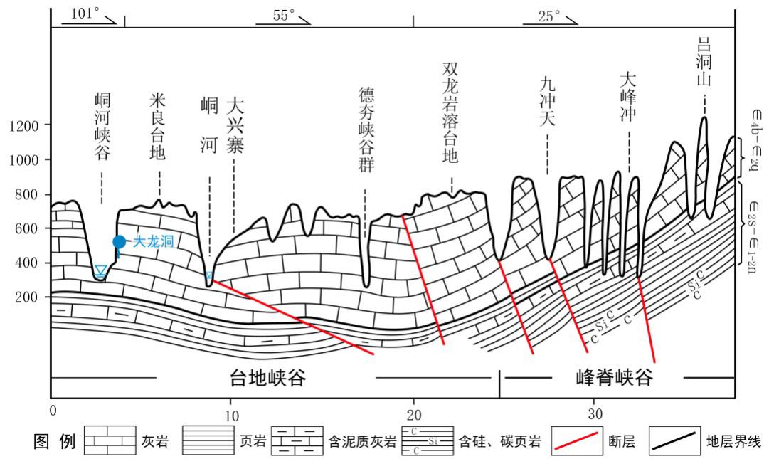
The platform-canyon karst landform is formed in three stages: carbonatite sedimentation, rock deformation and moulding geological remains (see Figure 1-19 & 1-20).
(1) Carbonatite sedimentation
The geopark, which sits in the southeast part of Yangtze Platform, adjacent to South China Continental Block (South China Active Zone), is a foreland basin which developed on the basis of middle and upper Yangtze craton and experienced multistage tectonic evolution, and it evolved into stable platform development zone after Xuefeng orogeny. During the period of 520 - 440mn years ago, i.e., from the late part of early Cambrian to Ordovician period, the region was reduced to ancient Yangtze sea area and received a set of open sea and restricted platform facies carbonatite sediment. There was a set of thin-thick layer of carbonatite, i.e. the landscape rock formation of the platform-canyon karst landform extending along Yaxi - Lüdongshan - Shuitianhe and Dutangping - Red Stone Forest – Furong Town. During the mid-Permian and early Triassic period after Caledonian movement and Hercynian movement, or 270mn-240mn years ago, as the depression of the rift valley in Yangtze Continent intensified and expanded, Xiangxi Region became a epicontinental sea far off the then trough and received a set of platform - inter-platform basin - tidal-flat facies carbonatite intercalated with argillaceous rock and siliceous rock sediment, being the landscape of karst landform in Luota part of the geopark.
(2) Rock deformation
At the end of mid-Triassic period, Yangtze continental plate and South China continental plate came across following their nearly 200mn years of pause. Due to the south-eastern plates collision, the concurrent collision between the northern Qinling Mountains and Dashan, as well as the southern Tethys moving northward, the two plates entered their activation stage when South China continental plate continued to obduct towards Yangtze continental plate, resulting in collision of the two continents, the main act of the Indosinian movement, the geopark uplifting to become a continent and the termination of sea invasion. Because of the compresso-shearing nature and expansion in the Indosinian - Yanshanian period, the north-eastern regional big fracture (Zhanghua Fracture, Malichang Fracture, Guzhang - Jishou Fracture) became activated, coming with three subsequent secondary fractures: north (north)-eastern compresso-shearing fracture, east-western strike-slip fracture and north-western compresso-shearing fracture. The joint and fissure development with high angle (larger than 60°) in the fault zone made the preparation for the forming of karst landform in the geopark. The joints and fissures are roughly divided into five groups as below:
Group A: runs in south-north or approximately south-north direction (350° -15°)
Group B: runs in north-north-east direction (20° - 30°)
Group C: runs in north-west direction (290° - 330°)
Group D: runs in north - east direction (40°- 60°)
Group E: runs in approximately east-west direction (70°- 100°)
Since the Tertiary period, Indian Ocean plate and Pacific plate collided in succession with Eurasian plate, the geopark was slowly uplifted, becoming part of the expansive Yunnan - Guizhou Plateau. Due to the reemerging activities of the major fractures in the geopark, differential uplift and tilting deformation occurred, resulting in gradually lowered base level of erosion, intensified hydrodynamism, denudation, erosion and corrosion. Consequently, the flowing water cut off the weak fissure zones between high-angle joints, fissures and fractures. The regional landform data showed that planation period consisted of two physiographic stages: Luota stage and Xiangxi stage. As a result of the differential uplift since the quaternary system, four levels of planation surfaces can be found, which were at 1400 - 1200m, 1000 - 850m, 800 - 650m, 500 - 400m respectively, corresponding to karst platform surface and karst caves at different elevation.
(3) Evolution of platform-canyon karst landform
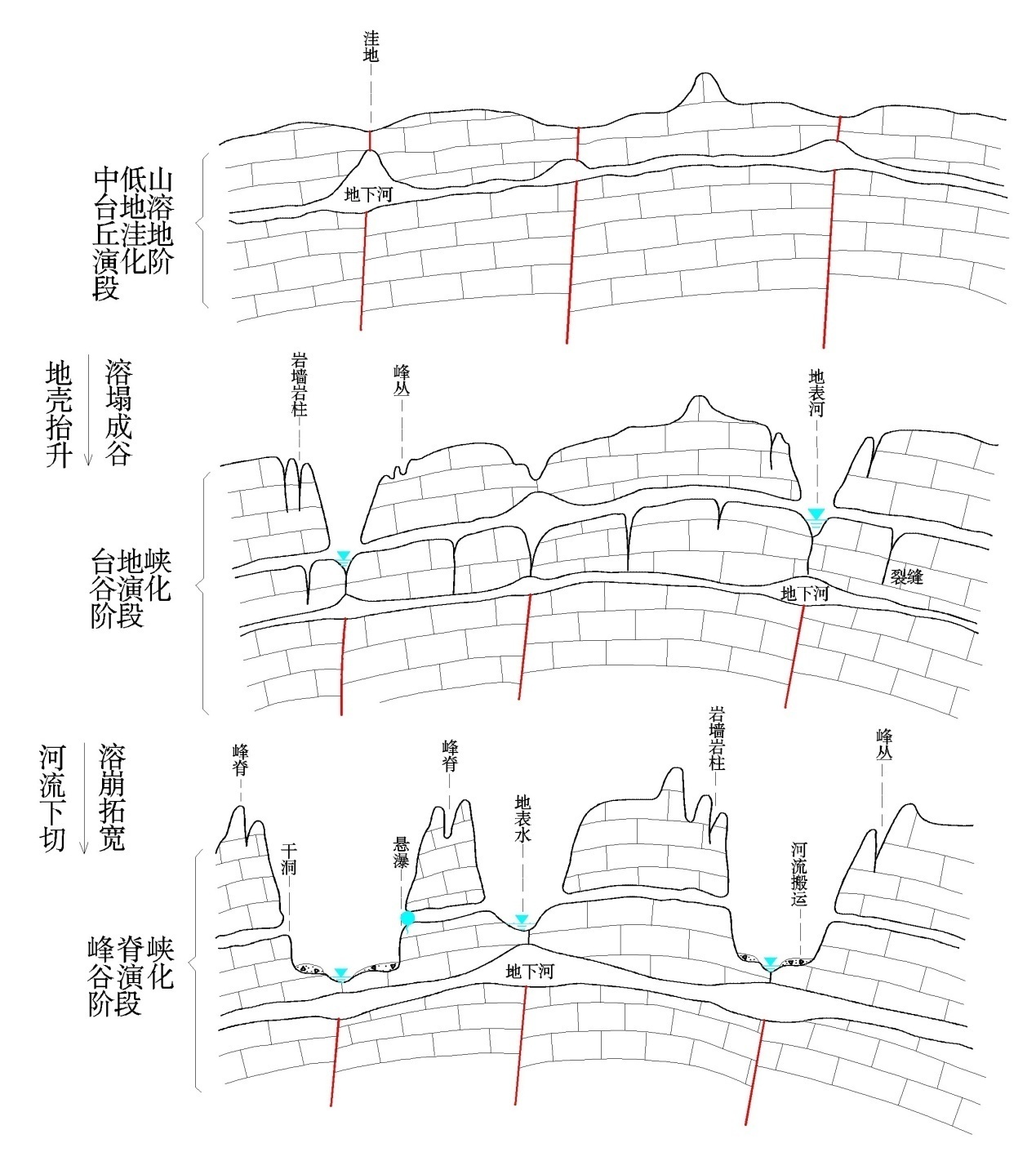
The geopark has developed surface and underground runoff, the intense erosion and corrosion of flowing water acts as the main external force in the forming of the geological remains in addition to the combined effects of gravitational collapse, mechanic handling and biochemistry. The precipitation and surface water performed downcutting, lateral erosion and headward erosion and intensified the separation and collapse of rock masses, widening and lengthening fissures to form ravines and canyons and incise karst platforms. That is how the current platform - canyon landform has formed. Its development and evolution can be divided into three stages: early stage (lower mid mountain-platform-karst hill-depression stage ), mature stage (platform - canyon stage) and late stage (ridge-canyon stage) (see Figure 8-20).

Figure 1-19 Donghe - Dehang - Lüdongshan Platform-Canyon Landform
a. Early stage (lower mid-mountain- platform-karst hill-depression stage)
This was the preliminary stage of corrosive tectonic landform in karst region. Due to the gaps in the fractures, joints and fissures, the platform karst hills were formed as a result of rain wash, long-time erosion and corrosion, with relative elevation of 50 - 150m. Karst hills looked like round steamed buns and the bedrocks were exposed, where karrens, depressions, dry valleys, karst caves and underground rivers are development. Luota Karst Platform, Dongmaku Karst Platform and Miliang Karst Platform were the examples of such a landform.
b. Mature stage (platform - canyon stage)
With the crust uplifting, declined base level of erosion and intensified down cutting, on the basis of lower mid-mountain-platform-karst landform, larger canyons were formed because the areas where there were fractures, fissures and joints, i.e., depressions, dry valleys and karrens, were slowly incised or karst caves collapsed. The karst landform here has the following characteristics: karsts, platforms and canyons are in alternative distribution; karst peak clusters and peak forests are developed at the edge of platforms; at the bottom of canyons or on the two-side cliffs are more often underground rivers or waterfalls; canyons, karst walls and waterfalls can be found everywhere in Aizhai, Shuitian River and Donghe River in the geopark. These canyons are lined with high mountains, cliffs and karst walls. They together form a picturesque landscape of blue and white.
c. Late stage (ridge-canyon stage)
As the platform-canyon karst landform continued to evolve, the karrens in the platform evolved into canyon and the karst peak forests and peak clusters continued to develop at the edge of the platforms. The previously formed canyons kept incising and widening with the declining area of the platform. After about 10,000 years, the platform-canyon karst landform will be ultimately developed into ridge-canyon karst landform having the following characteristics: dense distribution of canyons and brooks/rivers with ridges standing among them, narrow tops, more karst cliffs or upright karst walls, rolling hills and multi-level karst caves on the cliffs. One example is Lüdongshan Ridge-Canyon Karst Landform.
If the ridge-canyon karst landform continues to develop, they will ultimately turn into karst peneplain.

Figure 1-20 Evolution Stages of Platform- Canyon
QR Code


